UCF Google Street View 谷歌街景图像数据集
UCF Google Street View 谷歌街景图像数据集
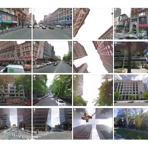
Google街景数据集包含62,058个高质量的Google街景图像。 图像覆盖了宾夕法尼亚州匹兹堡市中心和邻近地区; 奥兰多,佛罗里达州和曼哈顿部分地区以及纽约。
相关数据

交通信号识别视频数据(Traffic Lights Recognition (TLR))
Traffic Lights Recognition (TL... 免积分下载
Elektra自动驾驶数据集
Elektra 是一个自动驾驶汽车项目,由 CVC 研究中心... 免积分下载
戴姆勒行人检测标准数据库
该数据库采用车载摄像机获取,分为检测和分类两个数据集。 免积分下载数据介绍
Google Street View dataset contains 62,058 high quality Google Street View images. The images cover the downtown and neighboring areas of Pittsburgh, PA; Orlando, FL and partially Manhattan, NY. Accurate GPS coordinates of the images and their compass direction are provided as well.
For each Street View placemark (i.e. each spot on one street), the 360° spherical view is broken down into 4 side views and 1 upward view. There is one additional image per placemark which shows some overlaid markers, such as the address, name of streets, etc. The above figure shows sample street view images belonging to eight place marks of the dataset on the left. Sixteen sample user uploaded images which were used as query images in the related paper are shown on the right.
数据规格
| 图像数量 | 62,058 |
| 年份 | 2014年 |
| BibTeX |
@null{6710175, author={Zamir, A.R. and Shah, M.}, journal={Pattern Analysis and Machine Intelligence, IEEE Transactions on}, title={Image Geo-localization Based on Multiple Nearest Neighbor Feature Matching using Generalized Graphs}, year={2014}, volume={PP}, number={99}, pages={1-1}, keywords={Generalized Minimum Clique Problem (GMCP);Generalized Minimum Spanning Tree (GMST);Geo-location;feature correspondence;feature matching;generalized graphs;image localization;multiple nearest neighbor feature matching}, doi={10.1109/TPAMI.2014.2299799}, ISSN={0162-8828},} |